
U.S. First Solar and SolarCity, the main operators in the U.S. photovoltaic industry, have started using unmanned aerial vehicles (UAVs) to conduct business. UAV and related software were developed by Skycatch (San Francisco, Calif.), a start-up company established in 2013. The company has been funded by Google and others in the US during the seeding period.
Can also be used for animal and plant protection Skycatch company mainly provides general contracting services, complete sets of small UAVs that can take high-precision aerial images, and software for processing and analyzing collected images. The main customers are large-scale enterprises in construction, mining, agriculture, photovoltaic power generation and other industries.
UAV's use in photovoltaic power generation is to detect hot spots (abnormal heating) from tens of thousands or millions of solar cell modules using an equipped infrared camera. Compared with the one-by-one inspection of the module by the worker using the measuring device, labor costs can be significantly reduced.
In addition, UAVs can also be used to protect wildlife in large-scale photovoltaic power plants. In the United States, the construction of large-scale photovoltaic power plants must protect and manage the habitat of wild animals and plants. Using the UAV to cruise near the ground during the construction planning phase can confirm the wildlife in the planned area and take appropriate actions. And after the power station is built, UAVs can also be used to transfer the surrounding wildlife.
First Solar is the world's largest EPC operator (EPC means Engineering, Procurement, Construction) and is a CdTe solar cell manufacturer. The chief executive of SolarCity Inc. in the United States is the CEO of Tesla Motors in the United States, Elon Musk. First Solar and SolarCity used UAV's services to sign a contract with Skycatch, but did not disclose specific services.
First Solar will use Skycatch's UAV service in the world's largest 290MW photovoltaic power plant "Agua Caliente". Agua Caliente installed 5.2 million solar modules on 16km of land. In such a wide area, UAV should be able to fully exert its effect.
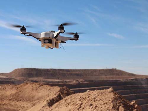
Automatic Battery Replacement UAV, developed by Skycatch, is a four-rotor helicopter that uses four rotors to generate lift. Weighing about 2.3kg, UAV is equipped with different sensors and cameras depending on the application. Although it is also affected by the weight of sensors and cameras, flight altitude and wind conditions, on average, it can fly for about 30 minutes at a time and collect 15GB of data. It is possible to obtain "ultra-high image quality" with a resolution of 1 cm/pixel or less. The UAV does not need to be remotely controlled from the ground, but autonomously flies along a programmed path.
After a flight is completed, the UAV will automatically return to the 61cm square called "GroundStation" and the approximately 45kg weight of the black box. The use of camera, GPS and ultrasonic sensors equipped to identify the location of the ground station, while using the wireless signal from the ground station to support UAV landing.
After the UAV has landed, the robot's arm will stick out of the box and replace the UAV's used battery with a new battery. The battery is equipped with a memory card that stores aerial images. The saved images are uploaded to Skycatch's servers via a wireless LAN.
The internal structure of the ground station, like a carousel, contains a number of batteries. The battery can be charged all the time, so there is no case where the fully charged battery is not enough. In other words, UAVs can fly dozens of times in large-scale power plant projects.
UAV will fly once within 30 minutes and upload data every time the flight is over. Skycatch's customers can get the latest data in real time. Skycatch will process and analyze the collected aerial data according to the client's requirements.
Diversification of use Through regular collection of aerial photography data, the progress of large-scale, large-scale civil engineering and construction sites can be managed and recorded. Construction companies can work more efficiently. Skycatch also provides 3D mapping of buildings and terrain based on aerial data.
Using the LIDAR (Light Detection And Range) system from the air, it is possible to determine the position, distance, and shape of an object over a wide range, to obtain data of the above-ground space, or to use for surveys of terrain and mines. In mines, ** is sometimes used to mine hard-to-reach coal seams. Using UAVs can confirm from the sky whether all ** have exploded to ensure safety.
In addition, aerial image data can be used to calculate the “normalized vegetation index (NDVI)†for reporting plant growth potential and density monitoring, drought and harvesting production, and forest harvesting.
In addition to the United States, Skycatch plans to conduct business in Europe, the Middle East, and Asia including Japan.
PPGI And PPGL With Different Designs
PPGL Sheet,PPGI Sheet,PPGI Profile Sheet,Galvanized Roofing Sheet
SHAOXING YOTO IMPORT&EXPORT CO., LTD , https://www.sxyotoes.com